HBSE 7th Class Social Science Solutions Geography Chapter 3 Our Changing Earth
Haryana State Board HBSE 7th Class Social Science Solutions Geography Chapter 3 Our Changing Earth Textbook Exercise Questions and Answers.
Haryana Board 7th Class Social Science Solutions Geography Chapter 3 Our Changing Earth
HBSE 7th Class Geography Our Changing Earth Textbook Questions and Answers
I. Answer the following questions:
Question 1.
Why do plates move?
Answer:
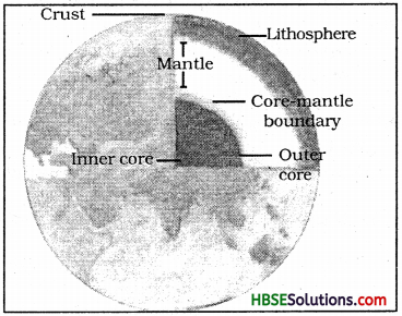
1. The lithosphere is broken into a number of plates known as Lithosphere plates.
2. These plates move around slowly a few millimeters each year.
3. It is because of the movement of molten magma inside the earth.
Question 2.
What are endogenic and exogenic forces?
Answer:
The earth movements are divided on the basis of the forces which causes them. The forces which act in the interior of the earth are called endogenic forces and the forces that work on the surface of earth are called exogenic forces.
Question 3.
What is erosion?
Answer:
Erosion is the wearing away of the landscape by different agents like water, wind and ice.
Question 4.
How are flood plains formed?
Answer:
During floods, layers of fine soil and other material called sediments are deposited on the river bank. This leads to the formation of a flat fertile flood plains.
Question 5.
What are sand dunes?
Answer:
An active agent of erosion and deposition in the desert is wind. When the wind blows, it lifts and transports sand from one place to another. When it stops blowing, the sand falls and gets deposited in hill-like structure called sand-dunes.
![]()
Question 6.
How are beaches formed?
Answer:
The sea-waves deposit sediments, beaches.
Question 7.
What are ox-bow lakes?
Answer:
An ox-bow lake is a cut-off lake formed due to cut-off of a meander loop.
Question 2.
Tick (✓) the correct answer.
(i) Which is not an erosional feature of sea waves?
(a) Cliff
(b) Beach
(c) Sea cave
Answer:
(b) Beach
(ii) The depositional feature of a glacier is :
(a) Flood plain
(b) Beach
(c) Moraine
Answer:
(c) Moraine
(iii) Which is caused by the sudden movements of the earth?
(a) Volcano
(b) Folding
(c) Flood plain
Answer:
(a) Volcano
(iv) Mushroom rocks are found in :
(a) Deserts
(b) River valleys
(c) Glaciers
Answer:
(a) Deserts
(v) Ox bow lakes are found in :
(a) Glaciers
(b) River valleys
(c) Deserts
Answer:
(b) River valleys
Question 3.
Match the following :
| (i) Glacier | (a) Sea shore |
| (ii) Meanders | (b) River of Ice |
| (iii) Beach | (c) Rivers |
| (iv) Sand dunes | (d) Vibrations of earth |
| (v) Waterfall | (e) Hard bed rock |
| (vi) Earthquake | (f) Deserts |
Answer:
(i) (c)
(ii) (b)
(iii) (a)
(iv) (f)
(v) (d)
(vi) (e)
Question 4.
Give reasons :
(i) Some rocks have shape of a mushroom.
Answer:
In deserts you can see the rocks in the shape of mushroom, commonly known as mushroom rocks because winds erode the lower sections of the rock more than the upper part. Therefore, such rocks have a narrower base and a wider top.
(ii) Flood plains are very fertile.
Answer:
At times the river overflows its banks this leads to the flooding of the neighbouring areas. As it floods, it deposits layer of fine soil and other material called sediments along its banks.
(iii) Sea caves are turned into stack.
Answer:
As the cavities of the sea caves become bigger and bigger only the roof of the caves remain thus forming arches. Erosion of sea arch breaks the roof and only walls are left. These wall like features are called stacks.
(iv) Buildings collapse due to earthquake.
Answer:
Buildings collapse because of the movement in tectonic plates under the surface of the earth which send out vibrations in all the direction causing an effect to anything built on the crust.
![]()
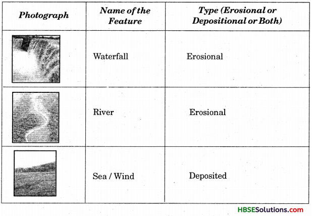
Question 5.
Activity:
Observe the photographs given below. These are various features made by a river. Identify them and also tell whether they are erosional or depositional or landforms formed by both.
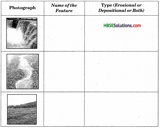
Answer:
Question 6.
Solve the crossword puzzle with the help of clues given.

Answer:
| Across | Down |
| 2. Look like bend of river | 1. Rise and fall of water caused by friction of wind on water surfaces. |
| 4. Solid form of water | 3. Flow of water in channel. |
| 7. Moving mass of ice | 5. Steep perpendicular face of rock along sea coast. |
| 9. Sudden descent of water in bed of river | 6. Debris of boulder and coarse material carried by glacier. |
| 11. Natural cavity of weak rocks formed by action of waves. | 8. Crescent shaped lake formed by river meander |
| 12. Embankment on river that keeps rivers in its channel. | 10. Fine sand deposited by action of wind. |
| 13. Large body of sea water. | 13. Isolated mass of rising steep rock near coastline. |
| 14. Dry area where sand dunes are formed. | 14. Alluvial tacts of land at mouth of river formed by river deposits. |
| 15. Small hill of sand piled by action of winds | |
| 16. Flat plain formed by river deposits during time of flood. |
Across:
2. Meander
4. Ice
7. Glacier
11. Cave
12. Cliff
13. Sea,
14. Desert
15. Sand-dune
16. Flood Plain.
Down:
1. Wave
3. River
5. Cliff
6. Hollows
8. Ox Bow Lake
10. Dunes
13. Beach
14. Delta.
HBSE 7th Class Geography Our Changing Earth Important Questions and Answers
Very Short Answer Type Questions
Question 1.
What are lithospheric plates?
Answer:
The lithosphere is broken into a number of plates known as the lithospheric plates.
Question 2.
What causes changes on the surface of the earth?
Answer:
The movement of the lithospheric plates causes changes on the surface of the earth.
Question 3.
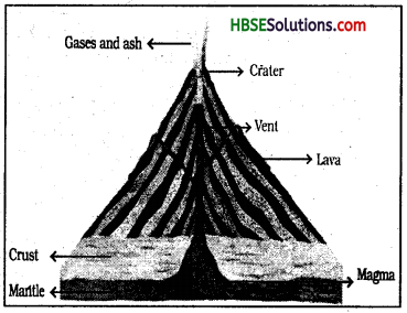
What is a volcano?
Answer:
A volcano is a vent (opening) in the earth’s crust through which molten material erupts suddenly.
Question 4.
When does weathering and erosion take place?
Answer:
Weathering and erosion takes place everywhere and at all the time.
Question 5.
What are dunes?
Answer:
Wind-blowing materials deposited in deserts are known as dunes.
Question 6.
Who are mineralogists?
Answer:
The scientists who study minerals are called mineralogists.
![]()
Question 7.
Name five rivers of the world which form a delta.
Answer:
Nile, Zaire, Ganga-Brahmaputra, Amazon, Murray—Darling.
Question 8.
Name four coastal landforms.
Answer:
Sea caves, sea arches, stacks, sea cliff.
Short Answer Type Questions
Question 1.
Draw a well-labelled diagram of a volcano.
Answer:
Question 2.
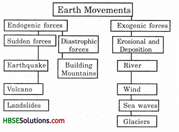
Complete the flow-chart given below:
Evolution of landforms
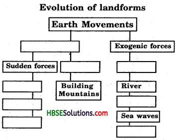
Answer:
Evolution of landforms
Question 3.
How is an earthquake measured?
Answer:
An earthquake is measured with a machine called seismography. The magnitude of the earthquake is measured on a Richter Scale. The following table explains the intensity of earthquake.
| Magnitude (Richter Scale) | Affect |
| (a) 2.0 or less | can be felt only a little |
| (b) Over 5.0 | can cause damage from things falling |
| (c) 6.0 or higher | very strong |
| (d) 7.0 or higher | major earthquake |
Question 4.
How do glaciers help in the formation of lakes?
Answer:
Glaciers erode the landscape by bulldozing soil and stones to expose the solid rock below. Glaciers carve out deep hollows. As the ice melts, they even get gilled up with water and become filled up with water and become beautiful lakes in the mountains.
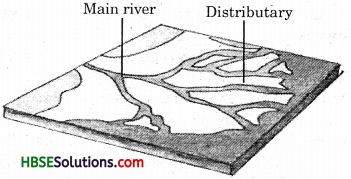
Question 5.
Draw’ a diagram of a delta and mark its (a) main river (b) Distributary.
Answer:
Question 6.
Define river load.
Answer:
The agents of wind, running water, glaciers and sea waves are constantly engaged in eroding rocks and many land surfaces. The minerals in rocks are also dissolved in water. These rock pieces, organic materials and dissolved minerals are called river load.
![]()
Question 7.
Give an account of earthquake preparedness.
Answer:
Earthquakes cannot be accurately predicted. However, we can minimise the impact if we are-prepared before hand.
During an earthquake, we should:
- Take a shelter under a kitchen counter, table or desk against an inside corner or wall.
- Stay away from fire places, areas around chimneys, windows that shelter including mirrors and picture frames.
- Spread awareness amongst our friends and family members.
Long Answer Type Questions
Question 1.
(а) sea cave
(b) sea arch
(c) sea cliff
(d) stack.
Answer:
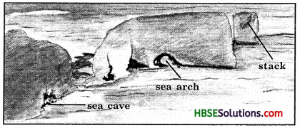
(a) Sea waves continuously strike at the rocks. Cracks develop. Over time they become larger and wider. Thus, hollow like caves are formed on the rocks. They are called sea caves.
(b) As the cavities of the sea cave, become bigger and bigger, only the roof of the cave remain, thus, forming sea arches.
(c) The steepy rocky coast rising almost vertically above sea water is called sea cliff.
(d) Erosion of sea arch breaks the roof and only walls are left. These wall like failures are called stacks.
Question 2.
Write about the work of a river. Explain with the help of a diagram.
Answer:
The following points explain the work of a river:
(a) The running water in the river erodes the landscape.
(b) When the river tumbles at steep angle over very hard rocks or down a deep valley side it forms a waterfall.
(c) While entering the plain the river twists and turn and forms large bends which are known as meanders.
(d) Due to continuous erosion and deposition along the sides of the meander, the ends of the meander loop come closer and closer.
(e) In the due source of time, the meander loop cuts-off from the river and forms a cut-off lake; which is also called ox-bow lake.
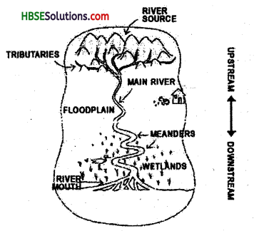
(f) Sometimes, the river overflows its banks causing flood in the neighbouring areas.
(g) As it floods, it deposits layers of fire, soil and other material called sediments along its banks.
(h) The fertile flood plain is formed. The raised banks are called leeves.
(i) As the river approaches the sea, the speed of the flowing water decreases and the river which begins to break up into several streams known as distributaries.
(j) As river becomes very slow and it begins to deposit its load.
(k) The collection of sediments from all the mouths formed a delta, which is a triangular landmass.
Our Changing Earth Class 7 HBSE Notes
- Weathering : Weathering is the breaking up of the rocks on the earth’s surface.
- Erosion : Erosion is the wearing away of the landscape by different agents like water, wind etc.
- Meanders : Large bends formed by twisting and turning of the river while entering the plain are called meanders.
- Ox-bow Lake : An ox-bow lake is a cut-off lake formed due to the cut-off of a meander loop.
- Leeves : The raised banks are called leaves.
- Glacial Moraines : The materials carried by the glacier such as rocks big and small, sand and silt get deposited, these deposits from glacial moraines.
- Waterfall : When the river tumbles at a steep angle over very hard rocks or down a steep valley side forms a waterfall.
HBSE 7th Class Social Science Solutions Geography Chapter 3 Our Changing Earth Read More »