Haryana State Board HBSE 6th Class Social Science Solutions Geography Chapter 7 Our Country India Textbook Exercise Questions and Answers.
Haryana Board 6th Class Social Science Solutions Geography Chapter 7 Our Country India
HBSE 6th Class Geography Our Country India Textbook Questions and Answers
Question 1.
Answer the following questions briefly:
(а) Name major physical divisions of India.
Answer:
The major physical divisions of India are :
- The Himalayas
- The Northern Indian Plains
- The Great Indian Desert
- The Peninsular Plateau
- The Coastal Plains
- The two group of islands.
(b) India shares its land, boundaries with seven countries. Name them.
Answer:
- Pakistan
- Nepal
- Bhutan
- Bangladesh
- China
- Myanmar
- Sri Lanka.
(c) Which two major rivers fall into the Arabian Sea?
Answer:
- Narmada river
- Tapi river.
(d) Name the delta formed by the Ganga and the Brahmaputra.
Answer:
Sunderban delta is formed by the Ganga and the Brahmaputra.
![]()
(e) How many States and Union Territories are there in India? Which states have a common capital?
Answer:
There are 29 states and 7 union territories in India. Haryana and Punjab have a common capital. Telangana is the new state included in India.
(f) Why do large number of people live in the Northern Plains.
Answer:
Large number of people live in the Northern plains of India due to the following reasons:
- These plains are generally levelled and flat.
- These are formed by alluvial deposits brought by the rivers.
- They provide fertile land for cultivation.
(g) Why is Lakshadweep known as coral islands?
Answer:
Lakshadweep islands are located in Arabian Sea. These islands are formed when the living polyps die and their skeletons are left. Other polyps grow on top the hard skeletons which grow higher and higher thus coral islands are formed.
Question 2.
Tick the correct answers:
(a) The southernmost Himalayas are known as:
(i) Shiwaliks
(ii) Himadri
(iii) Himachal
Answer:
(i) Shiwaliks
(b) Sahyadris is also known as:
(i) Aravali
(ii) Western Ghats
(iii) Himadri
Answer:
(ii) Western Ghats
(c) The Palk Straight lies between the countries:
(i) Sri Lanka and Maldives
(ii) India and Sri Lanka
(iii) India and Maldives
Answer:
(ii) India and Sri Lanka
(d) The Indian islands in the Arabian sea are known as:
(i) Andaman and Nicobar Islands
(ii) Lakshadweep Islands
(iii) Maldives.
Answer:
(ii) Lakshadweep Islands
(e) The oldest mountain range in India is the:
(i) Aravali hills
(ii) Western Ghats
(iii) Himalayas
Answer:
(i) Aravali hills
![]()
Question 3.
Fill in the blanks:
- India has an area of about __________.
- The Greater Himalayas are also known as __________.
- The largest state in India in terms of area is __________.
- The river Narmada falls into the __________ sea.
- The latitude that runs almost halfway through India is __________.
Answer:
- 3.28 million sq. km
- Himadri
- Rajasthan
- Arabian
- The Tropic of Cancer
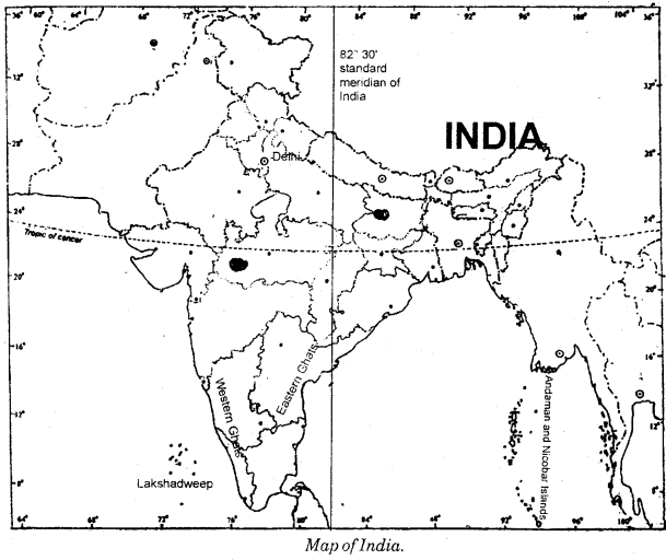
MAP SKILLS
On the outline map of India, mark the following:
(a) Tropic of Cancer
(b) Standard Meridian of India
(c) State in which you live
(d) Andaman Islands and Lakshadweep Islands
(e) Western Ghats and Eastern Ghats.
Answer:
HBSE 6th Class Geography Our Country India Important Questions and Answers
Very Short Answer Type Questions
Question 1.
What is the north-south extent of India?
Answer:
The north-south extent of India from Kashmir to Kanyakumari is about 3200 km.
Question 2.
What is the east-west extent of India?
Answer:
The east-west extent of India from Arunachal Pradesh to Kuchchh is about 2900 km.
![]()
Question 3.
What is extent of mainland of India?
Answer:
The mainland of India extends between 8°4′ and 37° 6′ N latitudes.
Question 4.
Why are there wide differences in local times of places located at two extreme points of India?
Answer:
There are wide differences in local time of places located at two extreme points of India because of great longitudinal deference.
Short Answer Type Questions
Question 1.
Describe the locational settings of India.
Answer:
- India is located in the Northern hemisphere in respect of latitudes and the Eastern hemisphere in respect of longitudes.
- The Tropic of Cancer (23°30’N) passes almost halfway through the country.
- From south to north mainland of India extends between 8°4’N and 37°6’N latitudes.
Question 2.
Describe the political and administrative divisions of India.
Answer:
- For administrative purposes, the vast country of India is divided into 29 states and 7 Union Territories.
- The formation of states have been made on the basis of languages.
- New Delhi is the capital of India.
- The states have further been divided into districts.
Long Answer Type Questions
Question 1.
How does the east-west extent of India affect time?
Answer:
The west to east extent leads to difference in local time from meridian to meridian. The local time changes by four minutes for every degree of longitude. The sun rises two hours earlier in the east, ie, Arunachal Pradesh than in the west, i.e., Gujarat. The local time of longitude of 82°30’E has been taken as the Indian Standard Time. This longitude is also known as the Standard Meridian of India. Its time is taken as the standard throughout the country.
Question 2.
What are the major physical divisions of India?
Answer:
The main physical divisions of India are:
Mountains:
(A) The Himalayas : The snow capped Himalayas lie are standing as sentiments is the north.
The three main ranges of Himalayas are :
- Great Himalayas (Himadri).
- Middle Himalayas (Himachal).
- Southernmost Range (Shiwalik).
(B) The Northern Indian Plains : They are formed by the alluvial deposits laid down by the rivers – the Indus, the Ganga, the Brahmaputra and their distributaries. These plains provide fertile land for cultivation.
(C) The Great Indian Desert : The Great Indian Desert lie in the western part of India. It is dry, hot and sandy stretch of land. It has very little vegetation.
(D) The Peninsular Plateau: The Peninsular plateau lies to the south of northern plains. It is triangular in shape. This is a region with numerous hill ranges and valleys.
![]()
Our Country India Class 6 HBSE Notes
- Alluvial deposits : These are very fine soils brought by rivers and deposited in the river basins.
- Tributary: A river or stream which contributes its water to the main river by discharging it into the main river.
- Peninsula : A peninsula is a piece of land that is surrounded by water on three sides.
- Island : A piece of land that is surrounded by water on all sides.
- Delta : An area of land formed at the mouth of the river. It is usually triangular in shape.
- Corals : Skeletons of tiny marine animals called polyps.
- Strait: A narrow passage of water connecting two large water bodies like seas and oceans.